On this page...
Iowa’s rivers and streams are popular destinations of Iowa anglers, with thousands of miles of rivers to fish across the state. Stream fishing has a particular fascination to people who enjoy Iowa’s natural landscapes and a unique angling challenge around every bend.
With many thousands of miles of rivers in Iowa, and many methods to fishing them, there are many theories, techniques, and so-called secrets of the trade. So where do you start?
Plan Your Fishing Trip
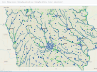
Browse hundreds of river accesses and county and state managed lake contours, miles of trout streams, over 2,000 fish structures, community fishing ponds, and Mississippi River Lock and Dam locations.
Popular Iowa Rivers
Learn more about fishing opportunities and practices along the two major Iowa rivers:
Other popular rivers that run through Iowa include:
- Cedar River
- Des Moines River
- Grand River
- Iowa River
- Little Sioux River
- Maquoketa River
- Soldier River
- Upper Iowa River
Yellow River
Back to topAll Iowa Rivers
| River | County | Location | Length in miles |
|---|---|---|---|
| Big Sioux River | Woodbury | 129.00 | |
| Boone River | Webster | 111.00 | |
| Boyer River (above Dunlap) | Crawford | 84.00 | |
| Boyer River (Dunlap to Missouri River) | Pottawattamie | Highway 30 bridge in Woodbine. Easting 275280 Northing 4623540 | 34.00 |
| Buffalo Creek | Jones | 48.00 | |
| Cedar River (above Nashua) | Floyd | This stretch is found in Chickasaw, Floyd, and Mitchell Counties. A popular multi-use location is the Charles City Whitewater Park in downtown Charles City on Hwy 14. | 63.00 |
| Cedar River (Cedar Rapids to Moscow) | Cedar | This stretch is found in Linn and Cedar County. A popular access is found in Palisades State Park which is on Hwy 30 between Cedar Rapids and Mount Vernon. | 55.00 |
| Cedar River (La Porte City to Cedar Rapids) | Linn | This stretch is located in Benton and Linn County. A popular river access is in the Dudgeon Lake Wildlife Area right of Hwy 150 on the North side of Vinton. | 56.00 |
| Cedar River (Moscow to Columbus Junction) | Muscatine | Saulsbury Bridge Recreational Area :•2007 Saulsbury Road, Muscatine, Iowa 52761 •From Highway 61 in Muscatine go 2.5 miles north on Mulberry Rd., then 4 miles west on Saulsbury Rd. | 32.00 |
| Cedar River (Nashua to La Porte City) | Black Hawk | North Cedar Park located on the north side of Highway 188 east of Plainfield is an excellent hard surface boat launch. | 77.00 |
| Chariton River (above Rathbun Lake) | Lucas | This stretch runs through Lucas and Wayne Counties. There are no boat ramps in this stretch. | 60.00 |
| Chariton River (below Rathbun Lake) | Appanoose | This stretch runs from the outlet of Lake Rathbun to the state line. Ramps are located in Outlet Park below Lake Rathbun and Sharon Bluffs access. Amenities listed are for the ramp at Outlet Park. | 31.00 |
| Coffins Creek | Delaware | Public access at Coffins Grove County Park | 14.30 |
| Des Moines River (Red Rock to Ottumwa Dam) | Wapello | This stretch runs through Marion, Monroe, Mahaska, and Wapello counties with 5 accesses: Howell Station, Eveland, Hardfish, Black Hawk River, and Black Hawk Road Accesses. | 47.00 |
| Des Moines River (Farmington to Keokuk) | Lee | Redwing Access : 3941 Valley Road just west of Keokuk. | 35.00 |
| Des Moines River (Humboldt to Stratford) | Webster | 53.00 | |
| Des Moines River (Hydropower Dam in Ottumwa) | Wapello | Inside Ottumwa city limits on the Des Moines River | 50.00 |
| Des Moines River (Ottumwa Dam to Farmington) | Van Buren | This stretch runs through Wapello and Van Buren counties. There are 11 boat ramps in this stretch. | 61.00 |
| Des Moines River (Saylorville to Red Rock) | Marion | A mid-section access point for this stretch of river is at the Pleasant Hill Boat Ramp. This ramp is located on SE Vandalia Drive immediately east of Highway 65. | 50.00 |
| Des Moines River (Stratford to Saylorville Lake) | Polk | The Highway 30 Access is in the middle of this river section and is located 3 miles west of Boone on the north side of Highway 30. | 57.00 |
| East Fork Des Moines (Algona to Humboldt) | Humboldt | 52.00 | |
| East Fork Des Moines (state line to Algona) | Kossuth | This stretch or river is in Kossuth County. Plum Creek Dam on 240th Street is a popular place to access the river. | 80.00 |
| East Nishnabotna River | Fremont | Red Oak city limits has river access and hard surface boat ramp | 123.00 |
| East Nodaway River | Page | 72.00 | |
| English River | Washington | Riverside Access : on the South side of Riverside. Has a hard surface ramp but it is only usable during highwater, mostly used as a canoe take out. | 37.00 |
| Floyd River | Woodbury | 114.00 | |
| Iowa River (above Iowa Falls) | Hardin | 49.00 | |
| Iowa River (Columbus Junction to Mississippi R) | Louisa | Cappy Russell Access : West of Oakville 6444 County Road X-71, Oakville, IA 52646 | 30.00 |
| Iowa River (Coralville Lake to River Junction) | Johnson | This stretch is located in Johnson County. A popular access is the Tailwater East Ramp located right below the Coralville Lake Dam, East of North Liberty and Coralville. | 29.00 |
| Iowa River (Iowa Falls to Marshalltown) | Marshall | This stretch is located in Hardin and Marshall County. A popular access is located in Pine Lake State Park, just east of Eldora on County Road S56. | 66.00 |
| Iowa River (Marshalltown to Coralville Lake) | Iowa | This stretch is located in Marshall, Tama, the SW corner of Benton, Iowa, and Johnson County. A popular access is at the Hwy 21 Access, which is part of the Iowa River Corridor Wildlife Area, just south of Belle Plaine. | 104.00 |
| Iowa River (River Junction to Columbus Junction) | Louisa | River Forks Access : 1001 Main Street, Fredonia, IA 52738 | 24.00 |
| Little Sioux River (Correctionville to Missouri R) | Harrison | Little Sioux Park, 2 miles SW of Correctionville, Woodberry County Conservation Board | 57.00 |
| Little Sioux River (Linn Grove to Correctionville) | Woodbury | 80.00 | |
| Little Sioux River (state line to Linn Grove) | Buena Vista | 97.50 | |
| Lost Creek | Jones | 0.35 | |
| Manchester Impoundment | Delaware | Manchester's newest addition of the Whitewater Park located in downtown Manchester. | 18.00 |
| Maquoketa River (above Monticello) | Delaware | Access points begin below the dam at Backbone State Park. | 68.00 |
| Maquoketa River (below Monticello) | Jackson | 82.00 | |
| Middle Raccoon River (above Redfield confluence) | Dallas | The best access is the hard surface ramp below the dam in the city of Redfield. | 110.00 |
| Middle River | Warren | There is not a public access to the Middle River within Warren County. | 127.00 |
| Missouri River (Council Bluffs to state line) | Fremont | Lake Manawa State Park: 1100 South Shore Drive/Council Bluffs, IA 51501 phone: 712-366-0220. Managed by the Iowa Department of Natural Resources Lake Manawa State Park has boat ramps on the Missouri River within the park. | 61.00 |
| Missouri River (Little Sioux to Council Bluffs) | Pottawattamie | Wilson Island State Recreation Area: 32801 Campground Lane/Missouri Valley, IA 51555 phone-712-642-2069. Managed by the Iowa Department of Natural Resources, Wilson Island Recreation Area has 544 acres along the Missouri River near Missouri Valley Iowa. | 53.00 |
| Missouri River (Sioux City to Little Sioux) | Harrison | Chris Larsen Park: 1280 Larsen Park Road/Sioux City, IA. Located on the Sioux City riverfront along the Missouri River. Larsen Park offers 110 acres on the Sioux City Riverfront. Managed by the City of Sioux City. | 64.00 |
| North Raccoon River (above Auburn) | Sac | 9.00 | |
| North Raccoon River (Auburn to Perry) | Greene | 87.00 | |
| North Raccoon River (Perry to Van Meter) | Dallas | A mid-section access point for this section of river is at the Highway 44 Access 4 miles west of Dallas Center. | 31.00 |
| North River | Warren | There is not a public access to the North River within Warren County. | 107.00 |
| North Skunk River (above Lynnville) | Jasper | The only public access above Lynnville is the carry down access in Homdahl Park on the SE side of Kellogg. | 46.00 |
| North Skunk River (Lynnville to Rose Hill) | Mahaska | This stretch runs through Jasper, Poweshiek and Mahaska counties. There are 2 accesses in Mahaska County at Union Mills and Robertson with carry down canoe launches. | 43.00 |
| Raccoon River (below Redfield confluence) | Polk | The best access for this stretch of river is the Walnut Woods State Park access off of Walnut Woods Drive 1 mile north of the Highway 5 bypass on the SW side of Des Moines. | 31.00 |
| Rock River | Sioux | 55.00 | |
| Shell Rock River (above Greene) | Floyd | Located in Worth, Cerro Gordo, and Floyd Counties. A popular access point is Wilkinson Pioneer Park located at the end of CR B20 in Rock Falls. This park is the start of the Shellrock River Greenbelt and Preserve featuring 7.5 mi. of scenic bluffs. | 58.00 |
| Shell Rock River (Greene to Shell Rock) | Butler | The city of Greene is located at the junction of Highway 14 and County Rd. C13. | 26.00 |
| Skunk River (Coppock to Mississippi River) | Des Moines | Mac Coon Access is located five and one-half miles north of Lockridge just east of Willow Blvd. | 65.00 |
| Skunk River (Rose Hill to Coppock) | Washington | McKain's River Access : Dogwood Avenue on the South side of the River. 3 miles North of Lake Darling State Park. | 110.00 |
| South Raccoon River | Guthrie | 15.00 | |
| South River | Warren | 63.00 | |
| South Skunk River (Cambridge to Pella) | Marion | A hard surface access is located South of Cambridge on the north side of Highway 210, 3 miles east of Interstate 35. | 58.00 |
| South Skunk River (Pella to Rose Hill) | Mahaska | This stretch runs through Mahaska County. There are ramps at the Glendale Access and the Rose Hill access. | 20.00 |
| South Skunk River (Story City to Cambridge) | Story | A mid-section access is the Sleepy Hollow Access off of West Riverside Road just east of Highway 69 on the north side of Ames. | 30.00 |
| Turkey River (above Clermont) | Fayette | This section of river includes the headwaters in Howard county and flows through Winneshiek and Fayette Counties. A popular access is at Vernon Springs Park just 2.5 miles southwest of Cresco. | 89.00 |
| Turkey River (below Clermont) | Clayton | This stretch is found in Fayette and Clayton County. A popular scenic and historical area is the Motor Mill Access about 8 miles southeast of Elkader on Galaxy Road. | 65.00 |
| Upper Iowa River (above Decorah) | Winneshiek | Find this stretch in Howard and Winneshiek County. A popular access is found in Kendallville Park and Campground off of Hwy 139 about 8 miles northeast of Cresco. | 79.00 |
| Upper Iowa River (below Decorah) | Allamakee | This stretch includes Winneshiek and Allamakee County. A popular access is at Lower Dam about 11 miles northeast of Decorah. | 57.00 |
| Volga River | Clayton | This stretch includes the headwaters in Fayette County and flows through Clayton County where it empties into the Turkey River just west of Garber. | 81.00 |
| Wapsipinicon River (Oxford Junct to Mississippi R) | Scott | Wapsi River Environmental Education Center : 31555 52nd Avenue, Dixon, Iowa 52745. Northeast of Dixon along the Wapsi River. And Sherman Park across the River in Clinton County | 66.00 |
| Wapsipinicon River (state line to Tripoli) | Chickasaw | This section includes Bremer, Chickasaw, Howard and Mitchell County. Twin Ponds Park has good access to the Wapsi River and is about 5 miles southeast of Ionia. | 88.00 |
| Wapsipinicon River (Tripoli to Troy Mills) | Buchanan | Most angling occurs below Sweet Marsh Reservoir or Highway 3 and south to Troy Mills. | 73.00 |
| Wapsipinicon River (Troy Mills to Oxford Junction) | Jones | This stretch is located in Linn and Jones County. A popular access on this stretch is in Pinicon Ridge Park, just off Hwy 13 by Central City. | 53.00 |
| West Fork Cedar River | Black Hawk | Best access locations are west of Highway 14 below the Big Marsh Wildlife Area in Butler County. | 68.00 |
| West Fork Des Moines (Emmetsburg to Humboldt) | Humboldt | 48.00 | |
| West Fork Des Moines (state line to Emmetsburg) | Palo Alto | 40.00 | |
| West Fork Grand River | Decatur | 41.00 | |
| West Nishnabotna River | Fremont | 121.00 | |
| West Nodaway River (above Villisca) | Montgomery | 52.00 | |
| West Nodaway River (Villisca to state line) | Page | 26.00 | |
| Winnebago River | Floyd | Located in Winnebago, Hancock, Worth, Cerro Gordo, and Floyd Counties. A good access point is East Park in Mason City. It offers excellent shore access to the river and a good starting point for a float trip down to the Averydale Access. | 72.00 |
| Yellow River | Allamakee | The headwaters of the Yellow River begin in Winneshiek County and flows through Allamakee County and the Effigy Mounds National Monument where it empties into the Mississippi River. | 53.00 |
River Fishing Tips & Techniques
Warmer water temperatures during the summer months increase the metabolism of bigger fish. They’ll be looking for food, which means more action on your line.
Flathead catfish are predators, so you’ll have the best luck with live fish as bait. Green sunfish and bullheads tend to survive best on the hook.
Many fish do their feeding after the sun has set. When fishing at night, think about using natural baits. These attract fish by both their appearance and odor.
Lastly, make sure you have your license and brush up on the laws in place to protect both you and the future of Iowa’s aquatic environments.
Where to Stand
It is crucial to choose your location on the river carefully, depending on what’s available and what you’d like to catch.
In river dams or natural barriers, the water just below is heavily oxygenated, which is able to host many types of aquatic life. This is where predatory fish like to lurk, such as walleye, sauger and paddlefish, as well as the smaller fish they feed on. Catfish tend to prefer stronger currents; find these closer to the main channel.
Other surefire locations to find fish are on the outside of river bends, pockets formed behind large boulders in the current, or at the joint of two merging streams.
Back to top